Recently Viewed ›
Recently Downloaded 
Close x
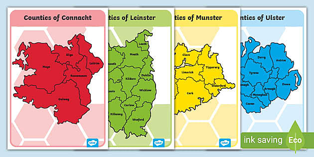
Once you've downloaded this wonderful resource bundle, you'll have access to 4 display posters that feature a map of each province, and their counties. Each province is given a different colour so that children can tell each one apart.
 counties of ireland
provinces
counties of ireland poem
map of ireland display
county colours
homophones worksheet
counties of ireland powerpoint
display
map of ireland
ireland counties
rivers of ireland
geography
counties of ireland display
counties of ireland
provinces
counties of ireland poem
map of ireland display
county colours
homophones worksheet
counties of ireland powerpoint
display
map of ireland
ireland counties
rivers of ireland
geography
counties of ireland display
Really Pleased to find these resources to cover the provinces one at a time without the distractions. Thanks!
geography display
Hi myjuly13,
Thank you very much for commenting! It's great to hear from you :)
 Lucy.B@Twinkl 7 years ago
LIke this resource, but work in a Gaelscoil and would love to see it in Irish
Hello beccaawalsh,
Thanks for commenting. I can see this being a useful addition - I'll pass your suggestion over to our translation team, to see if we're able to provide this. Because these requests require specialist input, they do take longer than other requests, but we will be back in touch if we can provide this. In the meantime, I have requested an editable version if you are able to provide your own translation. I hope this helps!
 Federica.P9176@Twinkl 8 months ago
Once you've downloaded this wonderful resource bundle, you'll have access to 4 display posters that feature a map of each province, and their counties. Each province is given a different colour so that children can tell each one apart.
By using this resource, children can learn all about the different regions in Ireland, and in which province each county belongs.
Simply download this resource to get started! If you're looking for something you can personalise, take a look at our editable version. Or even if you fancy creating a colouring exercise from this resource, we have a black and white version too.
If you found these provinces of Ireland maps useful in your classroom, why don't you take a look at more of our wonderful resources designed to aid and enhance learning on this topic? Explore some of our wonderful recommendations below:
All of our resources are designed by our specialist team and approved by experienced teachers to ensure that you're being provided with the highest quality of content. Perfect for helping you to easily plan and prepare your geography lessons in advance.
In total, there are four provinces in Ireland. They are Ulster, Munster, Leinster and Connacht.
 Home
Home  Membership
  TwinklCares
  Create
  Blog
Blog