Recently Viewed ›
Recently Downloaded 
Close x
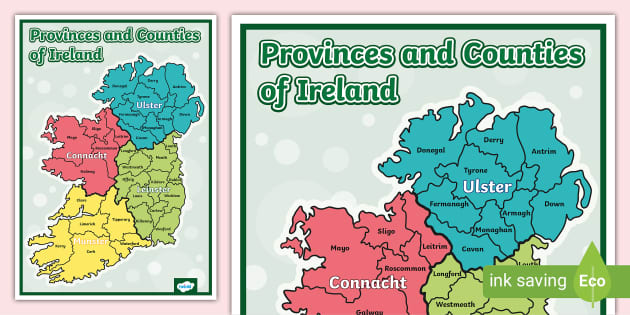
This is a colourful map of Ireland counties and provinces to help kids increase their knowledge of local geography. This is perfect for a 5th/6th class geography lesson studying county, regional and national centres.
 map of ireland counties
map of ireland
provinces of ireland
counties of ireland powerpoint
mountains of ireland
ireland map
ireland counties
counties of ireland map
ireland banner
map ireland
counties of ireland poem
time display
under the hawthorn tree
map of ireland counties
map of ireland
provinces of ireland
counties of ireland powerpoint
mountains of ireland
ireland map
ireland counties
counties of ireland map
ireland banner
map ireland
counties of ireland poem
time display
under the hawthorn tree
Can I please get an editable version of this resource so that I can translate it? Thanks!
Hi Bribri,
Thanks for your comment! I'll pass it over to our resource creation team, who will see if we can make this change for you :) Please let us know if we can help with anything else!
 jemmawa4@Twinkl 5 years ago
Hi there Bribri,
Our lovely resource creation team have completed this and emailed the new resource to you. It will be available on our website soon! I hope you like it!
 joe.hart@twinkl.co.uk 5 years ago
Is it possible to get this as Gaeilge or editable so I could translate it myself?
Hi MuinteoirAoifeNiRiain,
Thanks for commenting! I can see this being a useful addition - I'll ask our translation team to take a look at providing this translation. Because these requests require specialist input, they do take longer than other requests, but we will be back in touch if we can provide this :) In the meantime, I have requested an editable version if you are able to provide your own translation. I hope this helps!
 Rose.M2805@Twinkl 5 years ago
Hi there MuinteoirAoifeNiRiain,
Our lovely resource creation team have completed this and emailed the new resource to you. It will be available on our website soon! I hope you like it!
joe.hart@twinkl.co.uk 5 years agoThis is a colourful map of Ireland counties and provinces to help kids increase their knowledge of local geography. This is perfect for a 5th/6th class geography lesson studying county, regional and national centres.
This resource includes a beautifully colourful map of Ireland showing the counties and provinces. It's eye-catching and simple, so your children will be able to find the name of all the provinces and counties easily.
This map of Ireland showing the counties is an ideal display resource. Having it on your classroom wall will make it easy for your children to refer to whenever they need. Why not use this map as part of a fabulous display? You could pair this map with the County Crests Display Pack to teach your children a little more about each of the counties.
You could put this map of Ireland counties onto your whiteboard to study it as a part of a whole-class activity, or print out copies to hand out to your class. Try splitting your class into 4 groups and assign each of them one of the Irish provinces. They could research some interesting facts about each of the counties in their province, then present what they've found to the rest of the class.
You can download and print the map of Ireland showing the counties and provinces quickly and easily, so there's no need for lots of preparation to create a wonderful classroom display or inspire a fun class activity.
Geography is a core subject in schools, and it's important for kids to understand the layout of their country and have a basic understanding of the counties/provinces of Ireland. Both 3rd/4th class and 5th/6th class pupils will find this a useful visual aid.
Why not play a memory game? How many counties can they remember without looking at the display poster?
And why not check out these, similar resources:
There are 32 counties in Ireland, and they reside within the four provinces of Ireland: Munster, Ulster, Connacht and Leinster. There are 6 counties in Northern Ireland and 26 in the Republic of Ireland.
Counties in Northern Ireland:
Antrim, Armagh, Londonderry, Down, Fermanagh and Tyrone.
Counties in the Republic of Ireland:
Carlow, Cavan, Clare, Cork, Donegal, Dublin, Galway, Kerry, Kildare, Kilkenny, Laois, Leitrim, Limerick, Longford, Louth, Mayo, Meath, Monaghan, Offaly, Roscommon, Sligo, Tipperary, Waterford, Westmeath, Wexford and Wicklow.
Information about the Counties of Ireland
 Home
Home  Membership
  TwinklCares
  Create
  Blog
Blog